Walks from very easy short strolls to medium walks that are in remote locations. You can stand in an area of fifteenth century adeze (tool) manufacturing, walk in the footsteps of gold miners, visit a settlers graveyard where the mostly forgotten names of nineteenth century Nelson inhabitants are buried and you can experience the pleasure of being in a wildly remote, beautiful part of the South Island. Windswept beaches, extraordinary landforms, heritage and history are all free and easily accessible. Remember to follow the advice of the Department of Conservation. Ensure that heritage areas are left intact with only your footprints and wildlife is treated with respect. The following walks form part of Top picks things to do in Nelson Tasman region.
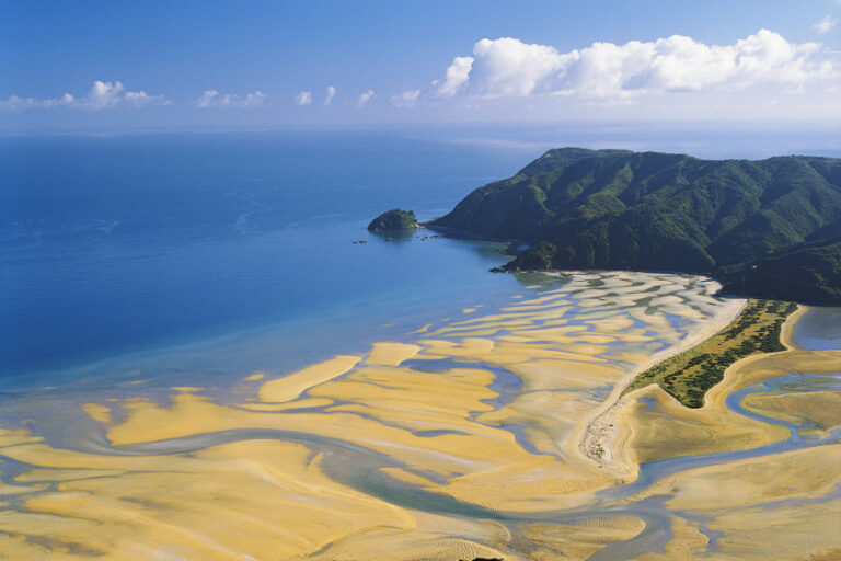
1.The Boulder Bank, Nelson
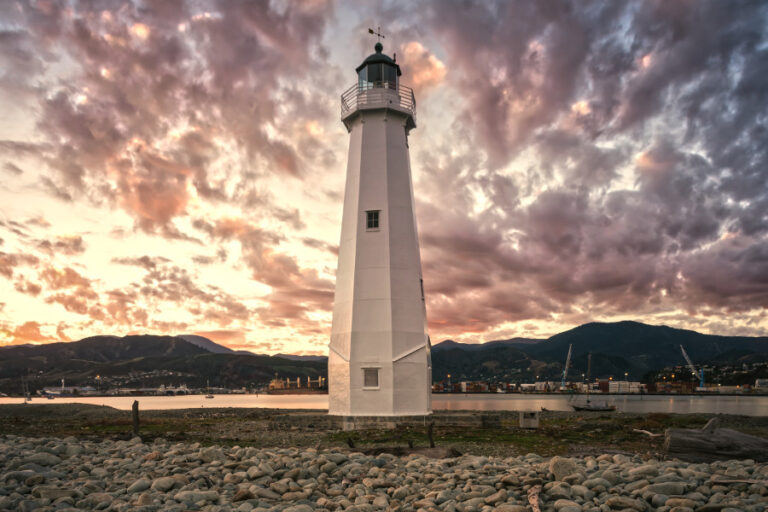
Perhaps a giant arranged the large boulders in a precise line reaching 13km into the sea forming an inlet. It is extraordinary that there are very few places in the world where the sea, tides, wind and nature create natural harbour barriers. The area is very exposed and strong footwear is required to walk on uneven ground. The area is rich in human history with camping and stone tools being manufactured for hundreds of years. You have excellent views of Nelson and the Tasman hills. And there is a lighthouse now, automated offering spectacular views of the city and hills.
Getting there
Access to the Te Pokohiwi/Boulder Bank is from Boulder Bank Drive (off Atawhai Drive (SH6)) or by boat from Nelson. A ferry service is available from Nelson. The Ferry operates visitor tours. You can climb all the way to the top of the lighthouse and enjoy the stunning view from the verandah. The Ferry is a comfortable way to check out the boulder spit.
- Dogs on a leash allowed.
- Length: 8 km one way
- Duration: Up to the individual to choose how far to walk.
2. Kawatiri Rail Tunnel
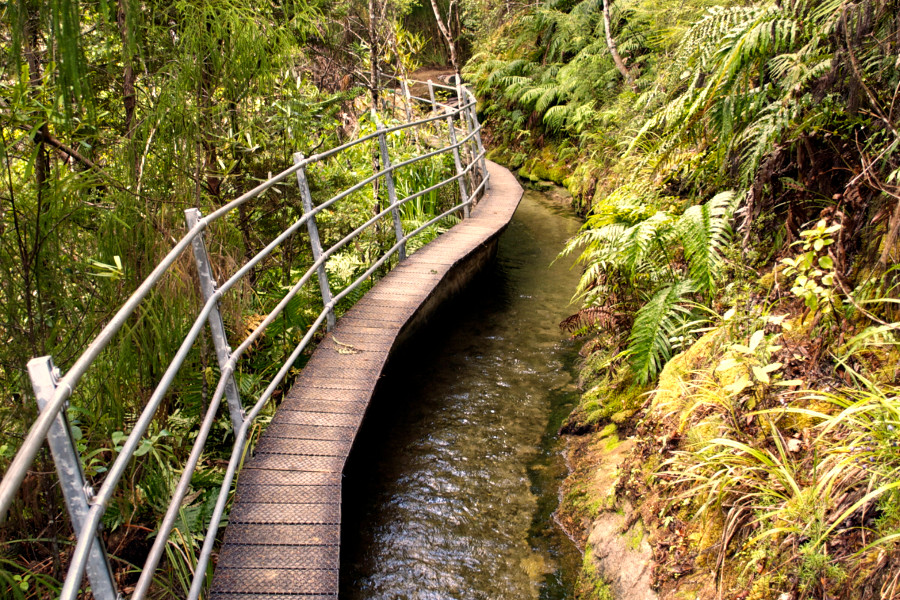
Kawatiri Junction at the intersection of SH6 and SH63, 35 km northeast of Murchison. There is an information shelter, picnic site and toilets beside the large parking area. The walk starts from a carpark with information panels detailing the rich history of the area. The Nelson to the West Coast coast rail link never completed and closed in 1955. The track follows the old railway embankment to the remains of the railway bridge, very photogenic and worth a moment to think about the men slogging in the bush building and hand cutting tunnels. The loop walk enters the tunnel with steps through the beech forest. A tunnel to nowhere is worth a detour.
After 200 metres the track crosses an old rail bridge before passing through a train tunnel built in 1923. A torch is helpful but not essential. The track returns via beech forest above the Hope River closing the loop at the entrance to the tunnel.
Dogs: on leash
Length: 1.5km loop track
Duration: 30 – 45 minutes
Grade: Easy
NOTE: insect repellent advisable
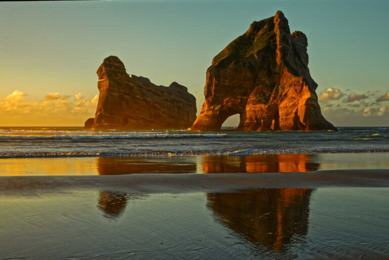
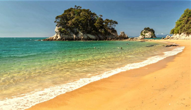
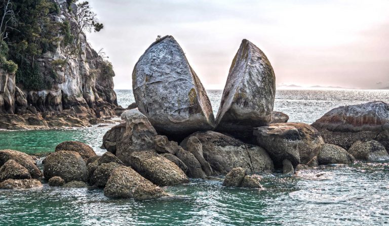
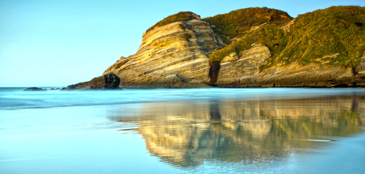
3. Split Apple Rock
Split Apple Rock beach has a magnificent view of enormous split rock, natural caves and a glorious gold sandy beach. The rock looks as though it is floating at high tide, however low tide provides more beach space and you can check out the rock up close as well as the caves at the northern end of the beach.
The rock’s legend is that two brothers fought over possession of the rock, to settle the argument the rock was split in half. The Maori name is Tokongawa or burst open rock. A great legend as the boys settled their differences and hopefully went for a swim afterwards on the glorious beach which is picture perfect for an instagram shot of the rock, the beach and the selfie.
Split Apple Rock is a big apple shaped granite rock formation split in half. It’s located between Kaiteriteri and Marahau at the southern end of the Abel Tasman National Park.
Dogs: In the boundary of a National Park, no dogs
Length: 400m
Duration: ½ day lazing on a beach (30 minutes return walk)
Grade: easy
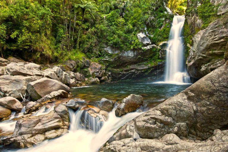
4. Wainui Falls Track
The track begins from a car park at Wainui Bay – look for the signpost about 300 m after crossing the Wainui River Bridge.
The walk starts by crossing framland then you enter the native forest of nikau palms, rata trees and tree ferns. The falls drop is over 20 metres onto granite boulders making for an impressive roar of water. Large water smoothed bounders litter the pool and are constantly wet, be careful not to slip.
The track is in good condition with a suspension bridge. Return to the Wainui Bay car park on the same track. The walk is popular with families and can be very busy throughout the day over the peak summer months when people flock to the Nelson/Tasman region. The best time to complete this walk is in autumn when there are fewer people in the area, and while temperatures remain warm after the summer. You’ll also get to appreciate the natural flair and colour of nearby Takaka, where the locals will always stop to chat.
Dogs: In the boundary of the National Park, no dogs
Length: 3.4 km (loop track)
Duration: 1 ½ hours return
Grade: easy
5
The Grove Scenic Reserve is about 8 km east of Takaka. At Clifton, turn off Abel Tasman Drive into Clifton Road, then into Rocklands Road. There is a small car park and picnic area about 1 km from Clifton.
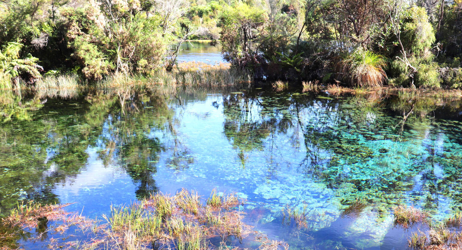
6. Te Waikoropupu (Pupu) Springs
A well known tourist attraction with excellent boardwalks, information plaques explaining the springs origins, significance to the local Maori, history of the springs in the last two hundred years and regulations around water safety as well as explanations of which areas are tapu (sacred).
The walk to the springs passes remains of water races for sluicing alluvial gold, attempts at farming and forest clearances. The land is now regenerating with mānuka and kānuka – indigenous plant ‘pioneers’ that re-colonise cleared forest areas and eventually make way for other species. Totora and rimu trees that have survived are markers for what the surrounding forest looked like originally.
Pupu Springs are the clearest spring water in the world, the welling waters cover an extensive area due to the water flow of ischarg 14,000 litres of water per second. This is a great walk for families with its interpretive history for New Zealand and the importance of the springs in New Zealand’s cultural identity.
Pupu Springs Nelson
Length: 800m
Duration: 30 minutes (return)
Grad: Easy
NOTE: DOC have described the areas as important for, “Bird and wildlife watching. This is a great place to go bird watching. The springs contain many indigenous macroinvertebrates, some rare or with very restricted ranges. These are prey to long-finned and short-finned eel, upland bully, red-finned bully, kōaro and a healthy population of giant kōkopu, one of New Zealand’s most threatened native fish. Within the forest areas korimako (bellbird), pīwakawaka (fantail), tūī, kererū (wood pigeon), riroriro (grey warbler) and silvereye are common, with fernbird observed occasionally in the pākihi (infertile wetlands). Kōtare (kingfisher), pūkeko, pūtakitaki (paradise shelduck), pārera (grey duck), kōtuku (white heron) and kōau (black shag) are regular visitors to the water.”
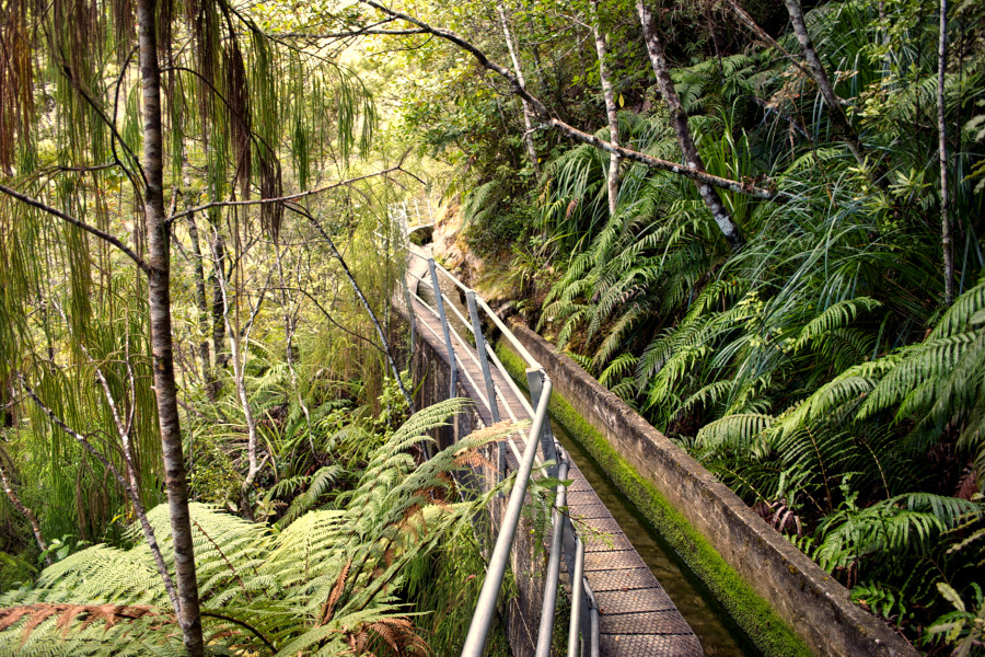
7. Pupu Hydro Walkway: Kahurangi National Park, Nelson/Tasman region
Pupu Hydro Walking Trail is a walk through gold mining sluicing history, one of New Zealand’s smallest electricity plants. A favourite walk due to native forest, the nineteenth century engineering history and the elements of the narrative that make this walk a New Zealand story.
Follow the road to Te Waikoropupu Springs, turn right just before the bridge crossing Waikoropupu River. The Pupu Hydro Walk Trail is signposted.
The Turbine house marks the car park, do not miss the viewing platform of the turbine house. “Although the climb to the water race line is a little steep, the first section, across Te Waikoropupū River to the power station is an easy grade suitable for all ages. Beyond the power station the track crosses Campbell Creek and zigzags upwards to reach the race after about 30 minutes’ climb. From here the track levels out and follows the race ‘upstream’ for a short distance to a lookout point above the power station.
Warning: From here on you are strongly advised to carry small children in a backpack and watch other children carefully; a fall from the race and the water itself are potentially dangerous.
The water race, which follows the steep contours of the hillside and is part canal and part aqueduct, was an engineering masterpiece for its time. If you look carefully in the water you might see large koura (freshwater crayfish).
The weir (the water intake), which marks the end of the walkway is a beautiful picnic spot. The weir channels water from the creek into the race; a large shutter was raised or lowered to vary the amount of water taken from the stream. The Hydro Society 4WD vehicle access track from the weir makes the walkway a loop walk (50 min) back to the carpark.
Pupu hydro walkway
Nature and conservation
Bird life is plentiful with an abundance of tui, bellbirds, weka and kereru (native pigeons). Robins and fernbirds live in the pakihi vegetation above the track.
Botanically the walkway is very interesting; the vegetation varies from mixed young beech-rimu forest to mature beech-podocarp forest. There is also a component of ‘cold climate’ plants: silver pine, mountain cedar and mountain toatoa, and a very rich fern component. One fern, Blechnum fraseri, looks like a miniature tree fern, while one of the mosses, Dawsonia superba, is the tallest moss in the world.
Pupu hydro walkway canal
History and culture
“Stretching along the hillside for more than three kilometres is the water race, an amazing feat of engineering, begun in 1901 and completed by eight men six months later in 1902. Large sections of the curving race were built on steep hillsides, running over several graceful aqueducts.
At the downstream end the water was piped downwards with a drop of 123 metres to give the gold sluices enough pressure to work the river gravels of the valley floor. The manager of the gold-mining company was Charles Campbell, after whom the creek and the race were named.
The company mined until about 1910 and then abandoned the workings. In terms of dividends paid for capital invested, this claim was the richest in Golden Bay. In 1929 the Golden Bay Electric Power Board built a small hydroelectric power station, which took water from the race. About half the length of the existing water race was used and the rest was left derelict.
Many Golden Bay residents were uncertain about whether to take the electricity generated; the power board had to run a promotion campaign to convince them of the advantages of this new technology. In June 1981 a fault developed, which engineers called a ‘flashover’. The generating equipment was extensively damaged and the power board decided it was too expensive to repair.
At that time, Pupu power station was thought to be the smallest station linked to the national grid. The Pupu Hydro Society restored the station and built a viewing area to allow visitors to see the station operating. It began generating again in 1987.” DOC online information Pupu Hydro Walkway: Kahurangi National Park, Nelson/Tasman region.
Know before you go
Supervise children on the Pupu Hydro Walkway, especially around the water race. Preferably carry small children in backpacks. Take care around sections of the Pupu Hydro Walkway track that climb up to the water race, they have deteriorated badly. Care is required when walking on these sections of the track.
Dog: Not allowed, the area is Kahurangi National Park
Length: 5.5 km
Duration: 2 -3 hours (loop)
Grade: Medium (supervision of children is necessary)
NOTE: Description of this walk is part of Pupu Hydro Walkway: Kahurangi National Park, Nelson/Tasman region.
8. Wakapuaka Cemetery Walk
This walk takes you round the historic Wakapuaka Cemetery where many of Nelson’s early settlers are buried. This walk has been prepared by Nelson Council.
Location: The memorial Mariano Gargiulo gates on Atawhai Drive. The cemetery is also accessible from Atawhai Drive north of the Miyazu Japanese Gardens.
Walk up the hill between the silver birches and rhododendrons – on your right is the memorial lawn. At the top beside the crematorium and chapel is a small gate to the Jewish section where the headstones are inscribed in Hebrew. Walk back down to the chapel and up the hill and over the cattle stop. On the left is a Wesleyan block and on the right the old Catholic block. Rosaline Frank (1864-1954), a noted photographer is buried here. There is also the Chapel of St Michael – known as Father Garin’s Chapel after Nelson’s first parish priest, Antoine Marie Garin (1810-89).
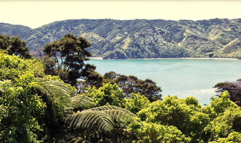
The Grove Scenic Reserve in Takaka, the Tasman District
Follow the road to the top of the slope where the Presbyterian section has some typically ornate Victorian headstones. From there take the road left and walk past the general block, with the Wesleyan block on the left.
James Smith Cross (1817-82), Nelson’s first Harbour Master is buried here. Enjoy the view of the city. Back at the junction on the right is the Anglican block which has the graves of well known water-colour artist John Gully (1819-88), and explorer and prospector George Fairweather Moonlight (1832-84). Leave the road a little way along and walk up the hill on the right. At the top is the obelisk memorial to the Maungatapu murder victims.
Either retrace your steps, or take the road beside the memorial and follow it round the back of the cemetery. Further down the hill, walk through the tall oaks and back up, noting the canning industrialist Samuel Kirkpatrick’s (c 1854-1925) grave on the right.
Follow the road past the grave of Edith Bunker (1916-96) on the right. Edith Bunker left a sizable donation to the local branch of the Salvation Army that helped fund their new premises. Veer to the left and take in the view of the Boulder Bank. On your right is the RSA section, then the Catholic section and a general section on the left. The old Presbyterian block is in front of you at the sharp right hand corner. Follow the road back down the hill and out the gates.
Thanks to the Nelson Branch of the New Zealand Society of Genealogists for developing this walk.
Dog: On leash
Length: Up to individual walker
Duration: ½ hour – 2 hours
Grade: Easy
9. Rush Pool, A walk through history of human occupation.
Start at the Maitai Valley car park just past the dam. Do not cross the pedestrian bridge over the Maitai River to the dun Mountain Trail, rather continue along the road that crosses the dam spillway. Where the 4WD track forks, built to service the transmission pylons that head over Maungatapu Saddle take the uphill track on the left, climb uphill and then swing to the right as signposted Rush Pool track which heads off up steps on your right.
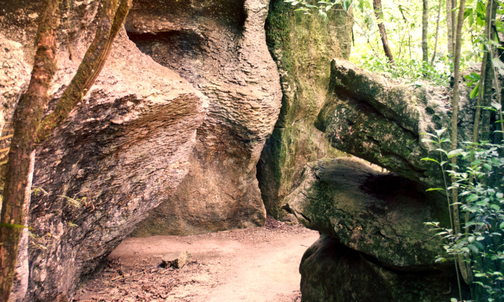
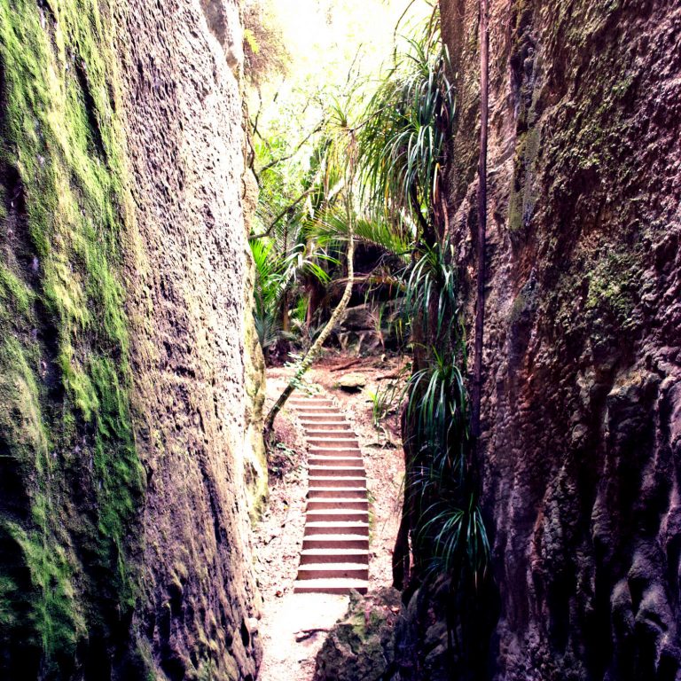
A walk into history where Maori fashioned tools (adezes) from the local argillite rock. The Rush Pool is a man-made pond, part of a site where tool making became an industry for the trading routes established in the late 16th century. Argillite was chipped from outcrops on the hillside and made into tools. Boulder Split provided the hard hammer rocks used to flake the argillite into shape. The original quarry face is evident, with numerous discarded argillite chips where the rocks were worked. As this is a heritage site nothing is to be removed from the location. There is no swimming in the pool. The man-made pool was part of the quarrying process. A fire was lit under the rock outcrop, then dousing the rock with cold causes shards to split and crack assisting with the extraction process.
Rush Pool is not picturesque or instagrammers delight rather it is a trip into the past where you layer your imagination with what happened. The walk following in the footsteps of people who tracked through the bush leading Pelorus and beyond. Early settlers used original tracks as bridle paths.
Length: 2.5 km one way
Dogs: No dogs
Duration: 3 hours return (loop)
Grade: Medium
10. Wharariki Beach
Remote over 100 km from Kaiteriteri, 2 km trail.
Windy, bent trees, people huddled against biting wind borne sand and insect repellent. Do not let this put you off. The best things are often the adventure getting there.
This walk is included as the destination is spectacular, extraordinarily beautiful with lush farmland, coastal views and a beach that is one of New Zealand’s best beaches for good looks.
Wharariki Beach
Wharariki Beach, Golden Bay
Windswept sand dunes, a beach where sculptured rocks are perched among the waves and incoming tide as artistic position pieces with the light creating shadows and depth.
The beach is only accessible at low tide. The thrill of playing catch up with the tide is a challenge and then there is the half hour drive from Collingwood to the camping grounds carpark. The start of the walk is through farmland, regenerating bush and over reasonably sized ridged sand dunes to get to the beach. There is a constant breeze often building up a bit of a blow into wind born sand particles, Then there are snoozing seals often covered in a fine layer of sand blending the seal into the surrounding gold sand.
Keep at least 20 metres from wildlife and always leave space between the sea and seal for their exit plans. Farewell spit is further along and the temptation to see what is at the end of the South Island means you will need to join an organised tour.
Farewell Spit is around 35km long and public access is restricted to the first 4km. Vehicle access is only allowed for supervised tours by concession holders. is around 35km long and public access is restricted to the first 4km. Vehicle access is only allowed for supervised tours by concession holders.
NOTE: Monitor the tide, and do not swim at this beach due to its powerful rips. The high tide can cut access off at either end of the beach.
Getting there
For walking buffs check out Abel Tasman top ten walks and Abel Tasman National Park for more walking destinations.
BEST BITS TRAVEL GUIDE